Our land is in demand. 26 square miles of land are used for housing each year, with huge pressure for development in the South East of England. 65 million of us live here, alongside billions of other creatures. Almost all our land is now managed and modified in some way, this has led to unimaginable loss of wildlife and habitat. When our food, water, air, our own and our children’s mental and physical health are beginning to be affected by nature’s decline, it is time to change things on a grand scale. And fast.
A national nature map for the UK
A national effort to recover our wildlife – and maps to chart the way
It starts with creating a nationwide map for nature, made up of lots of local maps, to show where wildlife is and where new habitats could be created. Maps like this could be used by, and developed with, farmers, housing developers, planners, conservation groups to guide habitat creation.
A number of Wildlife Trusts have created maps like this in counties like Somerset, Hertfordshire and Dorset. These have been produced with the help of local authorities and government conservation agencies. In some places these maps are already being used by councils to help make evidence-based decisions about where development happens. We believe that maps like this should be used across the country to show where nature is important and should be safeguarded, where land should be set aside for new nature, and where land could be used for housing and other activities without damaging the most important places for wildlife.
If maps like this were used across the country and used by farmers as well as planners the impact for wildlife could be extraordinary.
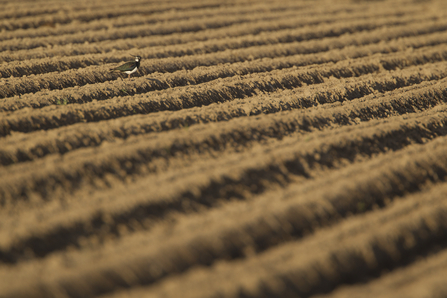
Lapwing on farmland ©Mark Hamblin/2020VISION
A nature recovery network
This year, the Government launched a 25 year plan for the environment, which included a commitment to develop a Nature Recovery Network - “to connect our best wildlife sites to overcome their isolation and fragmentation” [1].
We think this is exactly what is necessary to make more habitat to combat the ongoing loss of wildlife. We know that in order to make enough space for nature[2] to allow it to recover from huge losses over the past 50 years, we need to create more places for wildlife to live, over bigger areas, to manage these better and to join them up. A Nature Recovery Network should put this into practice in a nationwide plan for nature. And a nationwide set of local nature recovery maps would be the key to making this happen.
Creating the maps
The mapping itself is fairly straightforward. Local and national environmental and social data is used to identify areas where the greatest benefit for wildlife and people can be achieved, through extending or creating new areas of habitat to connect wildlife sites.
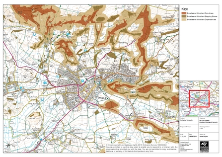
Scientific data is used to predict how species behave and move around the landscape. This is based on years of research and observation. This data can then be used to work out what amount of habitat is required and how much space there can be between patches of habitats for wildlife populations to survive. This leads to the creation of maps like the one below for an area in Somerset. Here habitat requirements were determined using data from 143 species found in Somerset. This map shows existing broad-leaved woodland habitats and areas of land where new woodland habitats could be created or targeted.
The maps can also identify where existing or new habitats are needed to provide essential services such as pollination, soil retention, flood water storage, water filtration and of course daily access to nature.
Although a national nature map is needed, it would be most practical to develop this in smaller units that can be pieced together to form a single national map. They would also need to connect over borders to the other UK countries.
An example nature map in Somerset
The maps below show the process of creating a nature map for woodland habitats in part of Somerset. It starts with mapping the best remaining areas of habitat (eg woodland nature reserves), then mapping the connections between them (eg smaller woods, copses) and then identifying the area of land where there is the most opportunity for creating new woodland habitats (eg through planting trees or natural regeneration of woodland).
These maps show woodland habitats - similar maps exist for other habitats like wetland and grassland. The maps would be merged together to form the basic Nature Recovery Network map.The maps would be used together.
This is the base map, showing Wells in Somerset and the surrounding countryside.
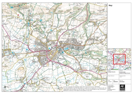
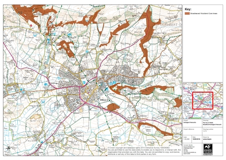
Stage 1: Map the most important existing areas of wildlife habitat
These are nature reserves, Sites of Special Scientific Interest, Local Wildlife Sites other areas of high quality natural habitats - our core sources of wildlife. These places need to be protected from harm, improved through good management and where possible increased in size.
The map below shows existing core areas of woodland habitat (shaded brown).
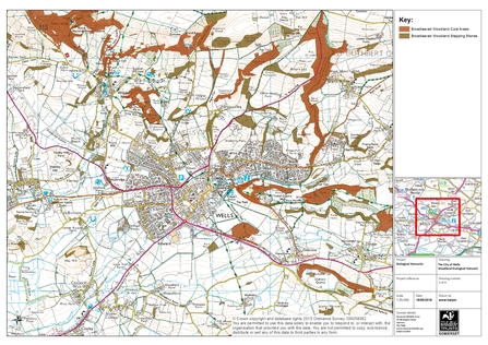
Stage 2: Map the connections between them
Smaller patches of habitat provide as 'stepping stones' and 'corridors' between bigger areas.
The map below shows existing patches of woodland 'stepping stones' and 'corridors' like small woods and copses.
Stage 3: Identify the best area for creating new habitats
By mapping our wildest places and the patches of habitat between them, we can identify the most effective area for creating new wildlife habitats and targeted wildlife-friendly land management. Here land management or development should be required to strengthen the network of habitats and not weaken it. This makes wildlife populations less likely to decline.
The map below shows a potential network for habitat creation and wildlife-friendly land management, providing a wider area for wildlife to expand and be able to move between woods.
Stage 4: Find space for wildlife in the wider landscape
This Network should sit within the wider landscape characterised by nature-friendly development and farming. This would include encouraging a wide range of people to increase the amount of wildlife habitat in places like farms, parks, retail parks, churchyards, road verges, gardens and golf courses. It would need high standards of basic regulation.
It is important that the maps are:
- Developed locally with the full involvement of everyone who can make them work - farmers, local planners, ecologists
- Evidence-based using the best available data and technology;
- Long-term but reviewed regularly;
- Part of a national network aligned with neighbouring Nature Recovery Maps to create a national Nature Recovery Network;
- Endorsed by Government statutory documents approved by the Secretary of State.
A common sense approach
Creating maps like this might sound like a lot of work, but consider the alternatives. At the moment farmers are paid to create or leave areas of wildlife habitat on farms. Developers often need to provide areas of habitat in and around new developments under proposals for ‘net gain’. Without a shared ecological plan for where habitats are located the activity is random and disconnected – creating patches of land for wildlife which aren’t big enough or close enough together to function ecologically.
And maps like this have already been created. It’s do-able and the cost would probably be less than two million pounds for the whole country. It is a big job to do but can we afford not to do it? I don’t think so…..
The data
Good quality data is essential to create reliable maps, national data sets are improving but often they lack the detail needed to plan practical action like creating habitats on farms. Much of the decision making about land use is also done at a county or district scale, which is why we are calling for government to legally require Local Authorities to publish local nature maps. These can then be used to plan land use and allocate development sites where they will have the least impact and where nature can be incorporated. They can also make sure that key wildlife sites are strongly protected as the base of nature’s recovery (critically, Sites of Special Scientific Interest and Local Wildlife Sites) and that other sites are protected for future restoration.
Government is already moving to increase availability of publicly held data and licences to use mapped information. However, it must be recognised that high-quality data is often held by small organisations that invest considerable resource in its collection, collation and administration. We need to find a way for such organisations, like Local Record Centres, to share data that will contribute to nature’s recovery without compromising their capacity to continue to collect and manage this information for the future.
Okay what needs to happen now?
The first step is to agree a national framework that sets out exactly what should be mapped, and identifies a common methodology, or ensures that methodologies used are complementary so that maps can easily be joined together to work at different scales. This should be agreed with input from existing local nature mapping initiatives, especially where these maps are already in use.
Planning policy already recommends that local planning authorities should map ecological networks so really this should already be happening. The Wildlife Trusts are calling for publication of these maps to be a legal requirement. It would be most cost effective to develop the mapping as part of their duty to cooperate with other authorities and for County Councils and Unitary Authorities to take a lead in producing county maps. These should be able to be divided into smaller sections or connected to form larger ones, depending on whether they are to be used for local authority area maps, regional projects or national maps.
The lack of ecological expertise in many Councils is a problem that needs solving but it need not be a barrier to the creation of these maps, as a mechanism already exists, through the Local Nature Partnerships, which brings together a range of relevant skills. Local Nature Partnerships were originally established in most areas in England and much of the existing nature mapping has been supported by them. Although some partnerships have dispersed due to lack of resourcing, it would not be difficult for Government to revive this initiative.
Once the maps are in place, legislation (a new Environment Act) would ensure that all public bodies used them when making plans and taking significant decisions affecting the use of land. Sustainable development principles should strongly encourage individuals, businesses and organisations that have significant land management responsibilities to have regard to them, using them to avoid damaging the natural environment as well as capitalising on the opportunities to create and join up wildlife habitats that the maps present.

